Add to Cart
UAV Overall
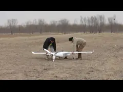
HXAYK-250 is a long-endurance tail-pushed VTOL with high efficiency specifically designed for long-range inspection, surveillance and mapping jobs, which can realize 3.5H endurance with 1.2kg payload.
Features of HXAYK-250 Drone
Mapping Application
In the UAV surveying and mapping combination, HXAYK-250 VTOL is equipped with HX technology multi-spectral camera and radio controller, with a remote control/data transmission range of 8km to 20KM, which can be used for crop status and water quality monitoring, resource investigation, etc.
Inspection Application
In the UAV inspection combination, the HXAYK-250 Industrial Drone can be equipped with a customized 30x zoom camera and ground control station with a 10km remote control/data/video transmission range, which can be used for remote inspections such as public security, border defense, and energy industries.
| HXAYK-250 Specification Aerial Mapping Drone | |
|---|---|
| Wingspan | 2500mm |
| Frame Weight | 3.2kg |
| Max. Take-off Weight | 15kg |
| Max. Payload | 2.2kg |
| Endurance | 3.5H@12.5kg |
| Max. Cruising Speed | 93.6km/h(26m/s) |
| Battery | 2x25000mAh Lipo |
| Stall Speed | 15.5m/s@12.5kg |
| Wind Resistance | 10.8m/s-13.8m/s(fixedwing); 5.5m/s-7.9m/s(vtol) |
FAQ for Product & Brand Customization
Q1. Can you customize according to my requested Aerial Mapping Drone parameters?
A: Yes. We have the support of the entire industry chain of industrial drones, so we can not only carry out the R&D, design, and production of industrial drones according to your requirements, but also give you many constructive suggestions based on our past case experience.
Q2. Can I make a sample order for custom drone?
A: Yes, we welcome sample order to test and check out quality.
Different samples in an order are acceptable.
Q3. Is it OK to print my logo on product?
A: Yes.
Q4. What about the lead time?
A:Sample needs 7-10 days.
Q5. Do you have any MOQ limit for drone?
A: We don't have any MOQ, 1piece is acceptable.
Q6. How to make an order for drone?
Step1: Let us know your requirements.
Step2: We quote according to your requirements or our suggestions.
Step3: Customer confirms the order and places deposit for formal order.
Step4: We arrange the production.
Q7. How do you ship the order and how long does it take to arrive?
A: We usually ship by air transportation.
It takes around 7-12 days to arrive in most situations. Sea transportation is also available.