... equipment. Update and upgrade on the previous generation, This product has nine mode to measure area or distance:Slope Mode, Fixed Width .....
Add to Cart
2022 Hi-target 8 core 2.0 GHZ GPS Land Surveying Equipment Hi-target V10 pro RTK Gnss Receiver price
Product Description 2022 Hi-target 8 core 2.0 GHZ GPS Land Surveying Equipment Hi-target V10 pro RTK Gnss Receiver price . Specification GNSS configur...
Add to Cart

1590 Channels Mapalys IMU SOUTH Star Navigation 2 RTK Differential system Galaxy GNSS Receive Overview Products Description GNSS Featu...
Add to Cart
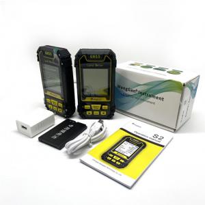
Qmini A5/A7 GIS Collector brings the essential functionality for high accuracy GIS data collection in one device. It is also the most cost-effective h...
Add to Cart
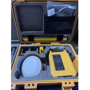
Gnss Receiver The V60 is a more compact-design and higher-performance GNSS RTK system, besides its rugged design...
Add to Cart
... Precision RTK Module Module GNSS Module Product descriptions from the supplier Overview Application: ● Location of base statio...
Add to Cart
CHC Brand Huayi E91 GNSS Receiver with 624 Channels for Specification: model CHC E91 Gnss Channel 624 Satellite Tracked L1CA/L...
Add to Cart
Land Surveying Equipment, GPS/Gnss Receivers, Mapping Lithium Ion Battery Lithium Battery 11.1V 6600mAh Pack We can make any customized battery for or...
Add to Cart
...Surveyor Tape Measure Dual-Sided Measuring Tape Product Description The 30-meter (100ft) Long Distance Fiberglass Surveyor Tape Meas...
Add to Cart
... with 5 times echoes ARS-200 high precision airborne LiDAR system is a Riegl LiDAR based mobile LiDAR system. It is developed and buil...
Add to Cart
...Camera 24 Megapixel Tilt Five Camera for Mapping Description Equipped with five high-pixel multi-angle tilt photography lenses, it can ...
Add to Cart
Key attributes Other attributes Place of Origin China Warranty 1 year Customized support OEM Brand Name FOIF channel 1408/800/394/336/555 Channels GPS...
Add to Cart
Galaxy G2 ● Ingenious & stylish design ● The extraordinary inbuilt radio ● Ultimate goals of full signals tracking ● Worry-free surveying ●The fact mo...
Add to Cart
... 1.4Hours Endurance UAV Camera 3D Mining Urban Modeling Aerial Mapping Drone ⇨Foldable Body The flexible and flexible design of the ...
Add to Cart
Data Acquisition System 20W 1.92km2 Triple Echo Livox Avia Laser Sensor UAV LiDAR System UAV LiDAR Scanning System with Triple Echo Liv...
Add to Cart
NLOS Long distance monitor video link for vehicles/armoured vehicle Introduction ST9520CZH Digital NLOS transmitter is of high power, high...
Add to Cart
Multiple Area Measure Mode Digital 1000meter Laser Rangefinder for FEATURES ● Min/max measurement ● Continuous measurement ● Stake-out fun...
Add to Cart
Grip and Slide Control Prism Pole Tripods Silver Color Heavy Duty Tripods 1.2m-1.8m Model: PTS ......
Add to Cart
SOUTH Total Station Surveying Equipment Best Price Automatic Total Station SOUTH Total Station NTS-332R10 Instrument Model NTS-332R10 Distance Measure...
Add to Cart