... Geosun GS-100E LiDAR Scanning System Application for 3D Surveying and Mapping GS-100E is a UAV measurement system independentl...
Add to Cart

... diodes, diode lasers or solid-state lasers. It can also be used for infrared microscopy, infrared luminescence, resolution performance and art res...
Add to Cart

UAV Mapping Drone Foldable Multifunctional Surveying and mapping UAV Drone With RTK HD Xcam /Multispectral Camera Xmission is an industry application-...
Add to Cart
Key attributes Industry-specific attributes Function With Camera Other attributes Material Aluminum/Alloy Operator Skill Level Expert Control Type Rem...
Add to Cart
High Stabilization Accuracy 3 Axis 1kg EO Sensor UAV Gimbal Camera TS01T is three- axis gyro stabilized gimbal UAV gimblal camera, support 360° contin...
Add to Cart
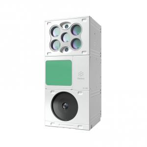
Key Benefits: Ruggedized, that integrate industry-leading thermal imaging with 4K visible imaging. Visible imaging adopts with f...
Add to Cart
OPTO-EDU A18.1843 Two Rings Observation A18.1843 Observation Spectrum White Light Purple Light 415nm ...
Add to Cart
..." fusion is realized for the first time in the industry, with better recognition accuracy; 2. For incomplete broken materials, a dual view multispe...
Add to Cart
FS-50 series multi-spectral The FigSpec fs-50 series is a new generation of pilotless from color spectrum technology, sui...
Add to Cart
... of flight time, the 1.6 kg / 3.6 lbs fixed-wing photogrammetry drone meets the highest standards of various industries. 3D, RGB, and...
Add to Cart