
Centimeter Level Accuracy GNSS RTK System Satellite Signals Tracked Simultaneously 220 Channels GPS……….. Simultaneous L1C/A, L2C...
Add to Cart
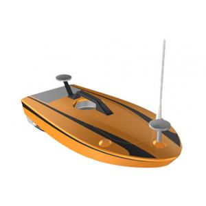
... Boat. Model No. HV-USV009 Hull Material Carbon Fiber and Fiber Glass Hull Length 105cm Hull Width 50cm Weight 12kg Payload 10kg ...
Add to Cart

Kolida 472R10L Wireless Reflectorless Staton Instruments Total Station Specification Models and technical parameters 472LL 472R4L 4...
Add to Cart
UAV LiDAR Scanning System Geosun GS-100C+ Livox Avia Topographic Surveying And Mapping Solution 5-Power supply Power supply for galvo head and control...
Add to Cart
China Superior Instrument RTK Positioning The V60 is a more compact-design and higher-performance GNSS RTK system, besides its rug...
Add to Cart
GPS Survey High Accuracy Land Distance Area Measuring Handheld GPS Surveying Units Normal area measurement of Handheld GPS Surveying Units 1. At the s...
Add to Cart
Multi platform highly integrated airborne LiDAR survey ARS-1000 with the range accuracy of 15mm@150m ARS-1000 airborne LiDAR survey is developed and b...
Add to Cart
... Equipment FOIF high-brightness color screen intelligent total station, built-in large-capacity memory and various application measurement...
Add to Cart
..., RTK can be used for building positioning, measurement, and monitoring of building structure to achieve high-precision building . ● In...
Add to Cart
... memory and various application measurement programs, powerful, stable performance, and easy to use. It is suitable for work such as buil...
Add to Cart
UAV LiDAR Scanning System GS 100C+ Livox Avia Topographic Surveying And Mapping Solution Drone LiDAR Scanning System Mounted on DJI M300 , with Livox ...
Add to Cart
Product Description: Total station is a measuring instrument used to measure angles and distances in topographic and geodetic surveys. It is a versati...
Add to Cart
...widely used in below fields, and are well received by worldwide surveyors and users. Land , Civil engineering, engineering Tun...
Add to Cart